|
3+ hours from Chisinau From the Nistru below Varenjeni – by the island in the river – you walk along the water or on a little dirt road that follows the river all the way to Naslavcea. From Naslavcea you can continue along the water on a path – there are ways to get up on the hill too to walk up there as well. At the bend of the river there is a really nice view of the monastary on the hill on the Ukrainian side. It is good to get up on top at that point as the path sort of disappears. After that you can just go back the same way you came along the water back to Verejeni. All along the water there are islands, forests, lots of birds, little houses on the Ukrainian side, rocks to jump off if you want to swim in the river, cows, the odd human and a different, red, “shaly” rockface to look at. Lots of nice spots to camp or just sit. Walking around the whole bend to end up at the Dniestr Hydro Power Complex is also nice. The whole way around the “bubble “ there seems to be fortifications from the second world war and the cliffs on the Ukrainian side are really spectacular with caves and such. The walking is easy on grassy, small roads BUT the walk is long. Past the Dniestr Hydro Power plant is an old quarry filled with water that is sort of turquoise. It is NOT worth it to walk all that way. Better to go back early and drive to the powerplant (pretty cool looking) and the quarry lake (not so cool looking) and have a look at it. We walked from Verejeni around the whole bend to the lake and then back to Naslavcea, down to the river again and back to Varejeni. It was 24 km. Needless to say – way too much unless you have lots of food. It took 7h or the like. 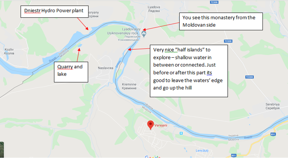 Go to Verejeni, Ocnita (there are other villages with the same name). The middle route is faster if you are google – BUT takes you through a village, across the fields and though the playground at the Casa Cultura in the village before Varejeni – scenic, really – but not for the faint hearted. Take one of the others if you want less adventure. 
0 Comments
2 hours from Chisinau Drive to Duruitoarea. In that village there is apparently a museum and caves with archeological digs. They have found iron age remains there. I have not seen it but it is probably interesting and it looks like there is a guest house there too. Start the walk from the Second World War monument. You can drive almost all the way to it or stop out by the tree lined dirt road that takes you there. Nice view, nice for picnics. Tall and steep so keep an eye on more experimental kids. From the monument you walk north as long as you want or as long as you have the energy to come back. There are hills to see all the way to the village Horodiste. You can start from there too and go the other way. There is a Hydro Power Plant in Costesti too – we did not see it.  When you get close to the village, don’t turn left down towards the village but go straight to the tree lined tractor road. 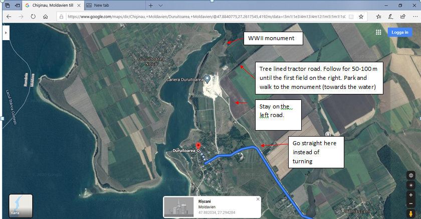 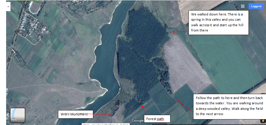 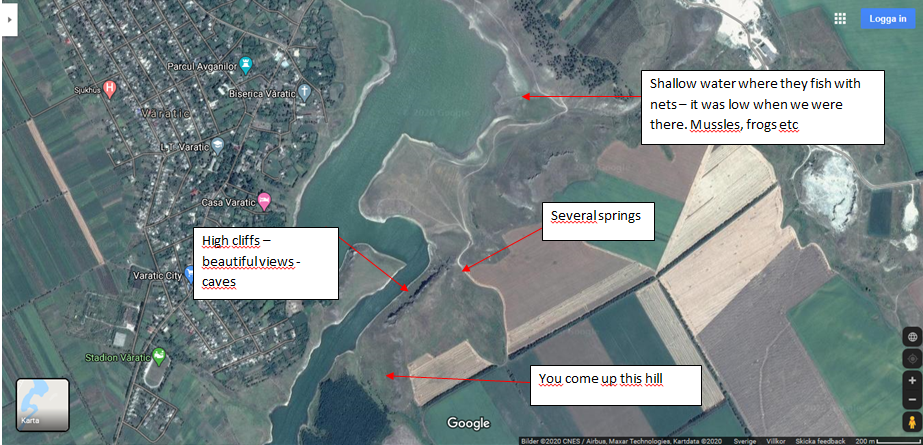 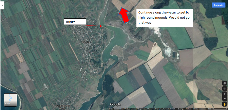 2 different possibilities to walk – waterfalls in both valleys all the way down. When you are in the smaller ravines leading to the main valley – follow the water in the small streams down to the main valley. Walking down either sides provides a bit of a challenge at times with climbing and small paths in some spots. If you are afraid of heights, it may not be the best for you. Then it is better to walk down the main path by the tree in the middle and then to the left or right on the valley bottom to see the waterfalls from below. Follow the water on the bottom of the main valley all the way out to the Nistru too. There are camping spots on the bottom of the valley. https://www.google.com/maps/place/Horodiste,+Moldova/@47.6131494,28.9327526,2114m/data=!3m2!1e3!4b1!4m13!1m7!3m6!1s0x40cc098173b31ccd:0x7ca62eef1686c697!2s%C8%9Aipova,+Moldova!3b1!8m2!3d47.6027726!4d28.9796465!3m4!1s0x40cc0a4bec8b5fb9:0xd293ca88a8b2e05d!8m2!3d47.6136602!4d28.9450023 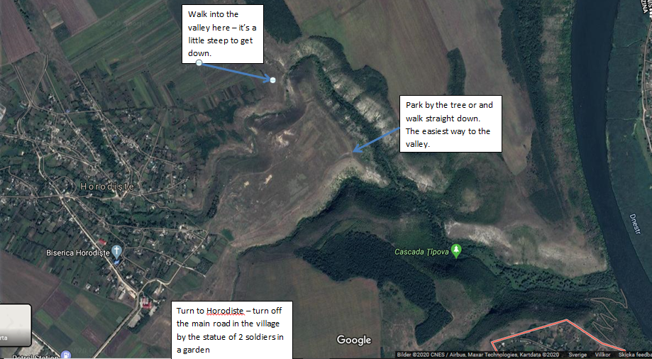 Speia – Serpeni – Aneni Noi region https://www.wikiloc.com/hiking-trails/speia-serpeni-48252043 - Map from another walker. We did not walk all the way to Serpeni – only around the corner of the bend in the river and than back through the forest. There are forest roads but we walked on paths along the water mostly. Sometimes not so much of a path, but possible to pass. Along the water there are lots of spots for picnics and camping, some even with tables and benches. From around the bend – we walked back through the forest- not always on paths but it was always passable. Halfway back we walked along the edge of the fields. It was at least 4-5 hours of walking and breaks as the walking along the water is slower than on forest roads. Lots of beautiful poplar and oak forest. Along the water closer to the bend – there are a few high poplar trees full of stork nests worth seeing. The field where you park is perfect for camping and picnics. At the forest edge, there are tables and benches and all along the forest edge is good for tents. 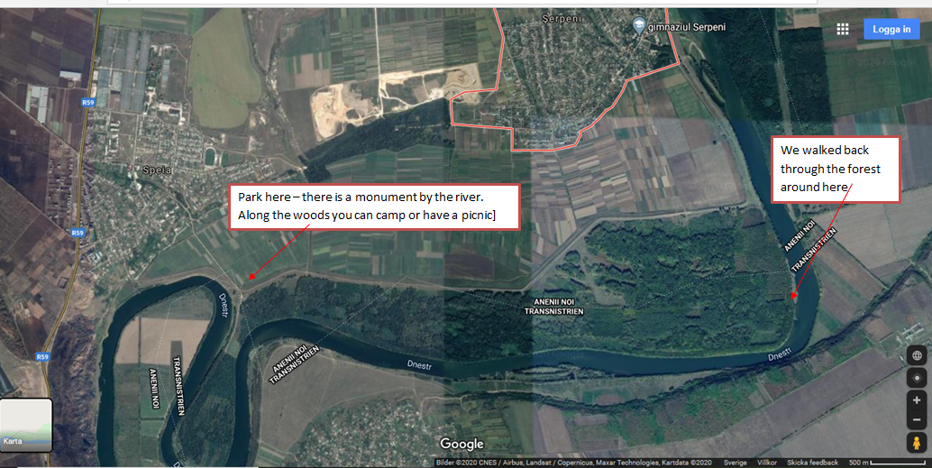 |
AuthorWrite something about yourself. No need to be fancy, just an overview. ArchivesCategories |
 RSS Feed
